
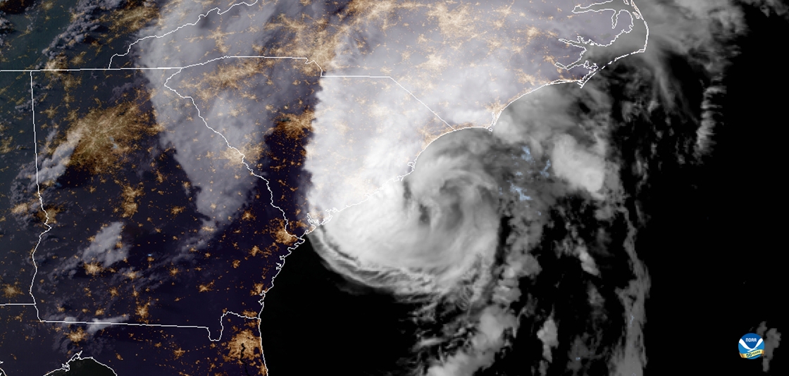
A coastal flood watch remains in effect as Hurricane Erin barrels toward the Outer Banks, threatening days of dangerous storm surge and life-threatening rip currents. Emergency officials warn the slow-moving storm could cause prolonged flooding, with peak impacts expected during Wednesday’s high tide cycles.
Beaches hundreds of miles from Erin’s center already report dangerous conditions, proving this hurricane’s far-reaching impacts. Residents and visitors are urged to monitor evacuation timelines and heed all safety warnings as the situation develops.
- Coastal Flood Watch remains active for North Carolina’s Outer Banks as Hurricane Erin approaches, with storm surge warnings continuing through midweek and tides expected to rise 4-6 feet above normal.
- Dangerous rip currents from Erin extend 300+ miles from the storm’s center, already causing drownings in New Jersey despite the hurricane’s distant offshore position.
- Critical erosion hotspots like Rodanthe face severe property damage, with 15-25 feet of dune loss since 2020 exacerbated by climate change-driven sea level rise.
- NC-12 highway faces multi-phase reopening, with full tourist access potentially delayed 7+ days due to anticipated overwash damage to this vital coastal artery.
Coastal Flood Watch: Hurricane Erin’s Threat Timeline, Rip Current Dangers, and Outer Banks Impact Guide
Coastal Flood Watch Remains in Effect as Hurricane Erin Approaches

The National Weather Service has extended coastal flood warnings through Friday along North Carolina’s Outer Banks as Hurricane Erin, now a Category 3 storm, continues its slow march paralleling the Eastern Seaboard. Meteorologists predict tides 4-6 feet above normal, with the most severe flooding occurring during Wednesday morning’s high tide cycle when lunar forces amplify the storm surge.
Three critical factors make Erin particularly dangerous:
- The storm’s slow forward motion (8 mph) prolongs coastal impact
- Unusually warm Gulf Stream waters (3°F above average) maintain hurricane strength
- King tides coinciding with storm surge create compound flooding risks

Evacuation Timeline for Vulnerable Areas
Emergency management officials have issued these critical time markers:
| Timeframe | Expected Conditions |
|---|---|
| Wednesday 6AM-Noon | Peak storm surge (+6ft possible) |
| Thursday Evening | First potential downgrade to advisory |
The Hidden Danger: How Erin’s Rip Currents Threaten Beaches 300+ Miles Away
Beachgoers from Florida to Massachusetts face lethal rip currents generated by Erin’s powerful wave energy, with drowning incidents already reported in New Jersey and Maryland. The science behind this phenomenon reveals how hurricane-strength waves propagate through deep ocean channels with minimal energy loss, creating dangerous conditions far from the storm’s center.
Current Danger Zones
- Outer Banks (Extreme Risk – Purple Flags)
- New Jersey Shore (High Risk – Red Flags)
- Cape Cod (Moderate Risk – Yellow Flags)
Outer Banks Erosion Crisis: How Hurricane Erin Exposes Climate Vulnerabilities
Coastal geologists measure 25-35 feet of dune loss in Rodanthe since 2018, with Erin’s prolonged assault expected to remove another 10-15 feet of shoreline. The combination of rising sea levels (3-5mm annually) and increased storm intensity creates an existential threat to barrier island communities.
Three doomed oceanfront properties demonstrate the crisis:
- The “Surf’s Edge” house now hanging over eroded cliffs
- A collapsed Airbnb rental filmed during Wednesday’s high tide
- NC-12 highway sections already under 3 feet of water
Hurricane Preparedness: What Most Visitors Forget
Beyond bottled water and flashlights, seasoned emergency managers recommend these often-overlooked items:
| Item | Critical Purpose |
|---|---|
| Waterproof document case | Protects IDs, insurance papers from floodwaters |
| Portable phone charger | Essential when power outages last days |
Evacuation Route Survival Tips
If ordered to evacuate:
- Leave before official announcements to avoid gridlock
- Map multiple inland routes – bridges may close unexpectedly
- Pack medications and pet supplies first
The Climate Connection: How Warming Waters Intensify Storms Like Erin
New research from NOAA shows warmer ocean temperatures increased Erin’s rainfall by 15% and wind speeds by 8% compared to pre-industrial era equivalents. The Gulf Stream’s record warmth (82°F in August) acts as an energy supercharger for Atlantic hurricanes.
Projected Storm Impacts by 2030
- 20% more Category 4/5 hurricanes expected
- Storm surge heights increasing 10-15%
- Hurricane season extending by 2-3 weeks
Road to Recovery: When Will Outer Banks Reopen After Erin?

The fragile NC-12 highway faces extended closures at known trouble spots like the S-Curves near Rodanthe. Transportation crews prepared for three recovery phases:
Phase 1 (0-48 hours): Emergency vehicle access only with temporary bridges
Phase 2 (3-5 days): Limited resident access with pilot cars
Phase 3 (7+ days): Full public access after debris removal
Comments