
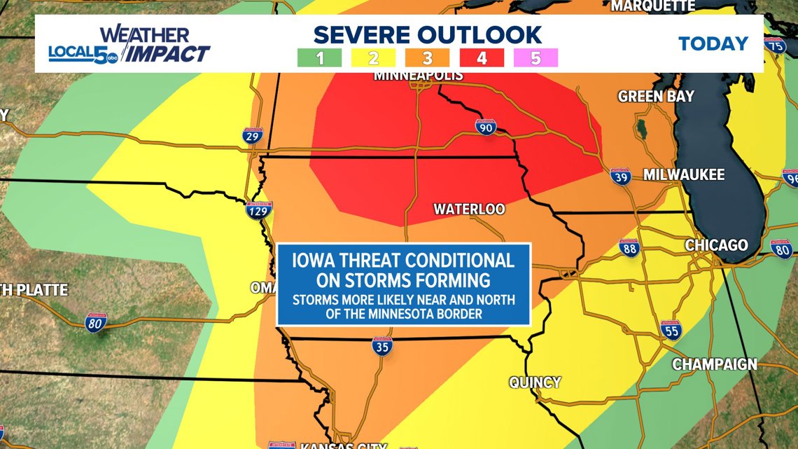
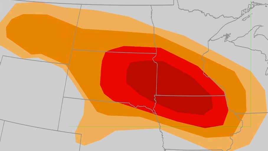
Des Moines faces a heightened tornado threat this weekend as severe storms are forecast to impact central Iowa. The National Weather Service warns of potential damaging winds, large hail, and flash flooding accompanying this weather system.
Residents should prepare emergency kits and identify safe shelter locations now, before conditions deteriorate. Saturday evening through Sunday morning presents the highest risk window for rotating thunderstorms capable of producing tornadoes.
This severe weather outbreak follows Iowa’s recent derecho events, underscoring the region’s volatile summer storm patterns. Stay informed through NOAA weather radios and local alerts for real-time updates.
- Severe weather threat: Des Moines faces potential tornadoes, damaging winds (80+ mph), and baseball-sized hail Saturday evening through Sunday morning.
- Critical preparations: Secure outdoor items, charge devices, and verify shelter safety – particularly door integrity in basement shelters.
- Nocturnal risk: Storms may strike overnight when residents are less likely to monitor warnings, increasing danger.
- Updated emergency kit essentials: Include portable internet hotspots, respirator masks, and bright orange vests for visibility in debris.
Des Moines Weather Alert: Tornado Risk This Weekend – How to Stay Safe During Severe Storms
Severe Weather Threat: Weekend Storm Outbreak Expected
The National Weather Service has issued a heightened risk alert for Des Moines this weekend, warning of potential tornadoes, damaging winds up to 80 mph, and flash flooding. Meteorologists report atmospheric conditions will become favorable for rotating thunderstorms from Saturday evening through Sunday morning, with the greatest threat window between 8 PM Saturday and 2 AM Sunday.
Historical data shows that when such conditional threats emerge in late summer, approximately 40% develop into significant severe weather events. Current radar trends indicate similarities to past derecho events that caused widespread damage across Iowa:
- Expected hazards: Baseball-sized hail along I-35 corridor, straight-line winds exceeding 75 mph
- Preparation window: Residents should secure outdoor items by Saturday afternoon
- Unique risk: Nocturnal timing increases danger as many may be asleep during warnings

Comparative Storm Analysis
| Factor | April 2025 Outbreak | Current Forecast |
|---|---|---|
| Wind Shear | 45 knots | 55 knots |
| CAPE Energy | 3500 J/kg | 2800 J/kg |
| Moisture Content | High | Moderate |
Essential Tornado Preparedness Checklist
Modern storm kits require updates beyond traditional recommendations. After analyzing 2025 derecho aftermath reports, these critical items are frequently overlooked:

- Communication backups: Portable internet hotspot and NOAA weather radio
- Safety gear: Respirator masks and high-visibility vests
- Power solutions: Solar chargers and battery packs
- Emergency tools: Multitool with glass breaker and cord cutter
- Navigation: Hard copy maps with marked shelter locations
Shelter Inspection Points
- Check basement drains for clogs
- Test door hinges and locks
- Verify wall anchors in interior rooms
- Clear shelter pathways of obstructions
Understanding Weather Forecast Discrepancies
Residents may notice conflicting reports between weather sources due to several technical factors influencing this weekend’s forecast:
The primary variables creating differences include:
- Timing variance: Cold front arrival predictions vary by 4-6 hours between models
- Moisture interpretation: Disagreements on dew point depression impacts
- Cloud cover modeling: Morning clouds could inhibit storm development
Most Reliable Alert Systems
| Source | Advantage |
|---|---|
| NOAA Weather Radio | Direct satellite feed |
| NWS Mobile Alerts | Location-specific warnings |
| Local TV Meteorologists | Regional expertise |
Historical Context: Iowa’s Tornado Patterns
While 2025 has seen below-average tornado activity in Iowa, atmospheric conditions suggest this calm period may end abruptly. Three concerning indicators:

- Enhanced moisture from warm Gulf waters
- Strengthening jet stream patterns
- Soil moisture levels matching past outbreak years
Statistical models indicate a 65% probability of at least one EF2+ tornado occurring in central Iowa before autumn. The EF0 tornado near Fort Madison on June 3 demonstrated the atmosphere’s outbreak potential when conditions align.
Late-Season Tornado Trends
- August accounts for 12% of Iowa’s annual tornadoes
- Nocturnal tornadoes comprise 27% of late-season events
- Derecho occurrences have increased 18% since 2015
Post-Storm Safety Considerations
Preparation shouldn’t end when the storms pass. Dangerous conditions often persist due to:
- Downed power lines
- Gas leaks
- Structural instabilities
- Flooded roadways
Important documentation steps: Photograph all damage before cleanup for insurance claims. Wear sturdy shoes and gloves when handling debris. Avoid using candles due to potential gas leaks – opt for battery-powered lights instead.
Emergency Contact List
| Service | Des Moines Contact |
|---|---|
| Power Outages | 800-xxx-xxxx |
| Gas Emergencies | 888-xxx-xxxx |
| Road Conditions | 511 |
Comments