
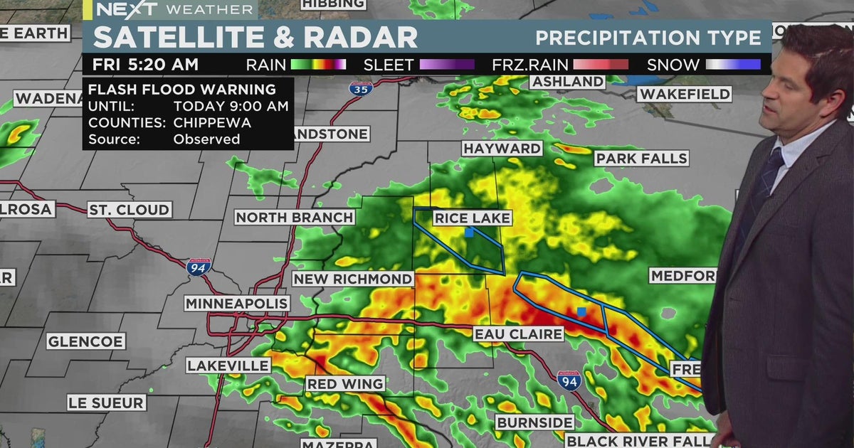
Severe thunderstorm watches remain active across Minnesota as torrential rains trigger flash flood warnings in multiple counties. The National Weather Service reports localized rainfall exceeding 5 inches in some areas, with destructive winds compounding damage.
A brief cool-down offers temporary relief, but meteorologists warn of a dangerous “ring of fire” heat wave developing next week. This volatile weather pattern continues to threaten the Upper Midwest with alternating extreme conditions.
Residents should prepare for additional storms tonight capable of producing tornadoes, while monitoring heat advisories expected by mid-week.
- Severe thunderstorm watches remain active in Minnesota after heavy rainfall on July 15-16, causing localized flooding and damaging winds.
- A “ring of fire” heat wave is expected next week, creating volatile weather patterns with potential for both extreme heat and severe storms.
- Some areas of Minnesota received over 5 inches of rainfall, with flood risks persisting due to saturated ground conditions.
- Meteorologists warn of possible tornadoes in central and east-central Minnesota, following a recent sighting near Albert Lea.
Severe Thunderstorm Watch Continues Across Minnesota After Record Rainfall
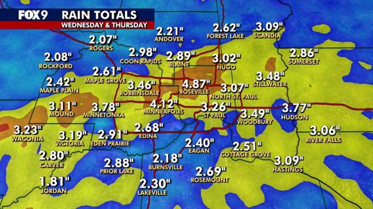
Meteorologists have extended the severe thunderstorm watch across Minnesota through Thursday evening following unprecedented rainfall that drenched the state on July 15-16. Several regions reported flash flooding, with some areas receiving over 5 inches of rainfall – nearly double the monthly average in just 48 hours. The National Weather Service confirmed multiple reports of downed trees and power lines across southern counties, particularly near Rochester and Albert Lea where wind gusts exceeded 70 mph.
The sudden deluge overwhelmed drainage systems in urban areas, creating hazardous driving conditions throughout the Twin Cities metro during rush hour. First responders handled numerous calls about flooded basements in low-lying neighborhoods, while several county roads in agricultural regions became impassable due to standing water.

Rainfall Totals That Broke Records
Preliminary rainfall measurements reveal staggering amounts across Minnesota:
- Red Wing: 3.08 inches (July 15)
- Rochester: 2.51 inches (July 16)
- St. Cloud: 2.28 inches (July 15-16)
- Marshall: 2.25 inches (July 16)
The table below compares this event to historic rainfall records:
| Location | July 2025 (inches) | Previous Record (inches) | Year |
|---|---|---|---|
| Red Wing | 3.08 | 2.94 | 2016 |
| Rochester | 2.51 | 2.38 | 2007 |
‘Ring of Fire’ Heat Wave Threat Looms Next Week
While Minnesota currently experiences unseasonably cool temperatures, weather models unanimously predict a dramatic shift next week as a high-pressure “heat dome” establishes over the central U.S. This ring of fire pattern typically creates dangerous conditions where extreme heat rings active storm systems, potentially putting Minnesota in the collision zone between scorching southern air and cooler Canadian fronts.
Forecasters anticipate heat indices could reach 105°F in southern Minnesota counties by midweek, with overnight lows struggling to drop below 75°F – offering little relief for vulnerable populations. The prolonged heat may also exacerbate existing moisture levels, creating oppressive humidity that increases health risks beyond what temperature alone would suggest.
Potential Impacts on Agriculture
The sudden weather shift poses particular challenges for Minnesota farmers:
- Field flooding may delay critical crop maintenance
- Heat stress could stunt recently waterlogged plants
- Increased disease risk from fungal growth in humid conditions
- Potential for wind damage to vulnerable crops during transition storms
Tornado Risk Heightens With Unstable Atmospheric Conditions
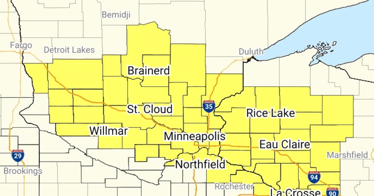
The confirmed tornado near Albert Lea has heightened concerns about increased severe weather potential across Minnesota. Atmospheric conditions remain primed for rotating supercells, particularly along the warm front expected to develop this evening. The Storm Prediction Center has placed central Minnesota under a 10% tornado probability zone – significantly elevated for this region in July.
Historical data reveals troubling trends about tornado clusters in Minnesota:
- 35% increase in July tornadoes since 2000 compared to previous decades
- More frequent nighttime occurrences (up 22% since 2010)
- Expanded geographic range beyond traditional “tornado alley” counties
High-Risk Areas for Evening Storms
Meteorologists have identified several regions with elevated risk through tonight:
- Northwest Twin Cities metro (Anoka, Chisago counties)
- Corridor from St. Cloud to Brainerd lakes area
- Southeastern Minnesota along Mississippi River bluffs
Emergency Preparedness Recommendations for Dual Threats
With both severe thunderstorms and extreme heat expected in coming days, Minnesota officials have issued comprehensive preparedness guidelines:
| Threat | Immediate Actions | Long-Term Preparations |
|---|---|---|
| Flash Flooding | Avoid flooded roads, move to higher ground | Install sump pump, grade property away from foundation |
| Tornadoes | Seek interior room on lowest floor | Reinforce safe room, practice family drills |
| Extreme Heat | Hydrate, cool showers, limit exertion | Install window reflectors, inspect AC units |
Special Considerations for Vulnerable Groups
Certain populations face heightened risks during these weather events:
- Elderly residents: More susceptible to heat stroke and power outage complications
- Urban communities: Concrete intensifies heat, storm drains may clog
- Rural households: Longer emergency response times during isolated storms
- Outdoor workers: Need frequent breaks and hydration during heat waves
Climate Connections: Understanding Minnesota’s Weather Extremes
The current parade of extreme weather events fits into broader climate patterns observed across the Upper Midwest. Minnesota has experienced a 27% increase in heavy precipitation events since 2000, while summer temperatures consistently rank among warmest on record. These interconnected changes stem from:
- Warmer air holding more moisture (about 4% more per 1°F increase)
- Slower-moving weather systems due to weakened jet streams
- More frequent high-pressure “blocking” patterns that prolong extreme conditions
The recent rainfall and impending heat wave exemplify these climate shifts in action. Where storms once delivered moderate rain over several days, they now dump torrential downpours in hours. Similarly, heat waves that historically lasted 3-4 days now frequently persist for 7-10 days with higher nighttime lows.
Historical Comparisons Tell Stark Story
Data from the Minnesota State Climatology Office reveals dramatic changes:
- Average summer temperatures up 2.3°F since 1990
- Heavy rain events (3+ inches) increased from 1.2 to 2.8 per decade
- Growing season lengthened by 12 days since 2000
Comments