
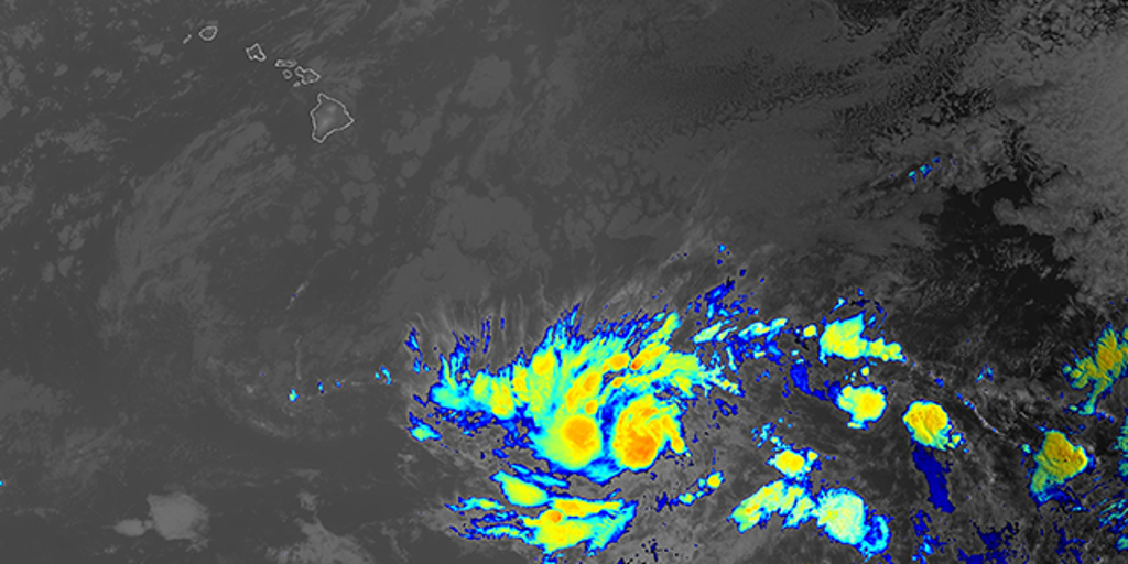
Tropical Storm Keli has developed in the Central Pacific, sparking concerns about potential intensification and impacts on Hawaii following Hurricane Iona’s recent formation. With sustained winds of 40 mph, Keli trails Iona’s Category 3 strength but shares a similar westward trajectory.
Forecasters are closely monitoring whether atmospheric conditions could allow Keli to strengthen into a hurricane. While current projections keep it south of the Hawaiian Islands, experts warn that even tropical storms can bring dangerous rainfall and surf to coastal areas.
- Tropical Storm Keli has formed in the Central Pacific with 40 mph winds, trailing Hurricane Iona (Category 3) as dual active cyclones.
- Current projections show Keli staying south of Hawaii, but its path remains uncertain due to potential interactions with steering currents and Iona’s outflow.
- While only 20% of Central Pacific storms become hurricanes, Keli’s broad circulation could bring heavy rainfall and high surf to Hawaii even without intensification.
- Historical comparisons highlight risks: Similar storms like 2024’s Hone unexpectedly strengthened near the islands, causing significant impacts.
Tropical Storm Keli Path Update: Will It Strengthen Into a Hurricane and Threaten Hawaii Like Iona?
Tropical Storm Keli Forms in Central Pacific
Tropical Storm Keli has developed in the Central Pacific Ocean, marking the second cyclonic system in the region alongside Hurricane Iona. With maximum sustained winds of 40 mph (65 kph), Keli currently poses no immediate threat to land as it moves westward at 12 mph.
The National Hurricane Center continues monitoring Keli’s development, though current models show it remaining well south of Hawaii. Ocean temperatures in the region are near normal, providing limited fuel for rapid intensification.


Comparison With Hurricane Iona
While Iona is predicted to weaken midweek, questions linger about Keli’s potential strengthening and trajectory. Both systems are moving westward, though current projections suggest Keli remains south of Hawaii—for now.
The two systems share similar formation areas, but critical differences exist:
- Ocean heat content: Iona formed over anomalously warm waters
- Steering currents: Keli faces stronger easterly shear
- Moisture availability: Dry air surrounds Keli’s circulation
| Storm | Max Winds at Formation | Peak Intensity |
|---|---|---|
| Keli (2025) | 40 mph | TBD |
| Iona (2025) | 85 mph | Category 3 |
Potential Impacts on Hawaii
While the current forecast keeps Keli south of the Hawaiian Islands, history shows these tracks often shift northward. Key preparedness considerations include flash flooding from outer rainbands and high surf along south-facing shores.
Hawaii’s mountainous terrain can amplify rainfall, creating dangerous situations even from weakening systems. The 2024 disaster on Maui demonstrated how tropical moisture can combine with local conditions to produce catastrophic results.
Emergency Supply Checklist
Residents should maintain basic readiness:
- 3+ days of water
- Non-perishable food
- Medications and first aid supplies
- Battery-powered weather radio
Forecast: Will Keli Strengthen Into a Hurricane?
The Central Pacific averages 4-5 tropical cyclones annually, but only 20% reach hurricane strength. Keli’s broad circulation and disorganized structure currently limit its intensification potential.
Most models show Keli weakening before reaching the International Date Line, due to increasing wind shear and cooler waters. However, any westward-moving tropical system bears watching for potential regeneration in the Philippine Sea region.
Historical Context and Future Projections
Keli’s characteristics demonstrate several atypical features for July storms in this region. The simultaneous presence of Hurricane Iona creates complex interactions in the atmosphere known as “Fujiwhara effects” which can alter tracks and intensities unpredictably.
Residents should remain vigilant and monitor official forecasts from the National Hurricane Center for updates on Keli’s trajectory and potential impacts. While not currently projected to make landfall in Hawaii, these systems can change direction quickly.
Community Reactions and Preparedness
The formation of two storms in the Pacific simultaneously has raised concerns among Hawaii residents. Some community members express worry about potential impacts, while others remain skeptical about media coverage of tropical systems.
Emergency managers recommend having a plan in place before storm threats materialize. Key steps include knowing evacuation routes, securing loose outdoor items, and preparing for possible power outages.
Lessons From Past Storms
Hawaii’s experience with tropical systems provides valuable insights:
- 2018’s Hurricane Lane caused catastrophic flooding despite weakening
- Tropical Storm Olivia (2018) caused widespread power outages
- 2024’s Hurricane Hone demonstrated rapid intensification near the islands
The best approach is to stay informed through official channels and be prepared to act quickly if warnings are issued. Even if Keli doesn’t directly threaten Hawaii, its formation serves as a reminder of the need for year-round preparedness in island communities.
Comments