
The Atlantic hurricane season intensifies as Invest 96-L shows signs of developing into a tropical depression, with forecasters warning it could strengthen into a hurricane. The National Hurricane Center gives this system a 70% chance of cyclonic formation within 48 hours, raising concerns for the Caribbean and potentially the Southeast U.S.
Warm ocean temperatures and favorable atmospheric conditions may fuel rapid intensification, while dry air could temporarily hinder development. Residents in vulnerable areas are urged to monitor updates closely as models suggest possible impacts by late next week.
This potential storm aligns with NOAA’s prediction of an above-normal hurricane season, marking 2025’s fifth named system. Historical patterns indicate significant risks for the Lesser Antilles if the current trajectory holds.
- Invest 96-L has a 70% chance of developing into a tropical depression or storm, with potential intensification into Hurricane Ernesto by late next week.
- The Lesser Antilles, Puerto Rico, and the Virgin Islands are at highest risk, with possible impacts including flash flooding, landslides, and storm surge starting August 16-19.
- Florida faces a 30% chance of impacts, depending on the system’s trajectory—either recurving out to sea (55%), brushing South Florida (25%), or entering the Gulf (20%).
- Record-warm Atlantic sea temperatures and a weak El Niño signal an above-normal hurricane season, with NOAA predicting 18-22 named systems in 2025.
Atlantic Tropical Storm Watch: Will Invest 96-L Develop Into a Hurricane and Threaten the Caribbean Next Week?
Atlantic’s Invest 96-L Shows Signs of Potential Hurricane Development
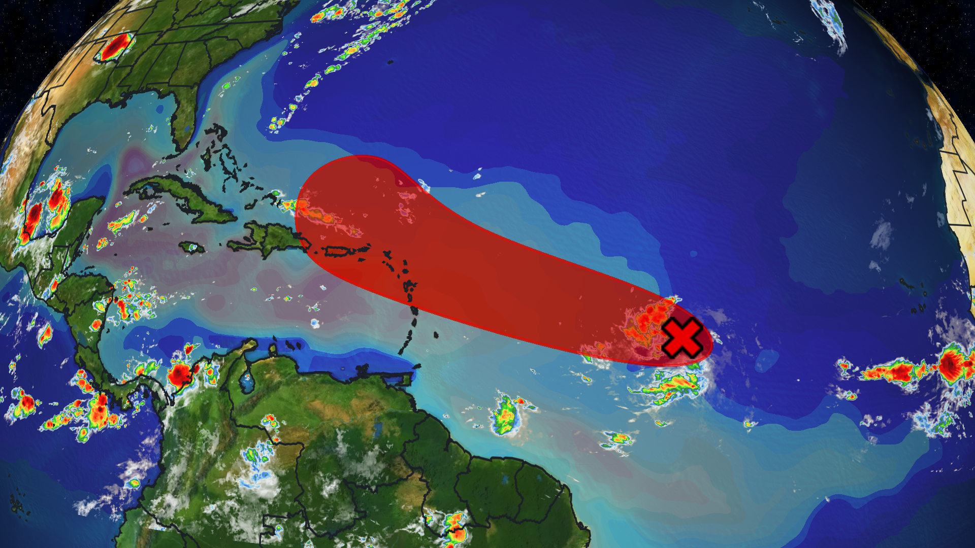
The National Hurricane Center (NHC) is closely monitoring Invest 96-L, a tropical disturbance in the eastern Atlantic that has a 70% chance of developing into a tropical depression or storm within the next 48 hours. This system currently exhibits sustained winds of 25-30 mph and organized convective activity, two key indicators of potential cyclonic development.
Meteorologists identify three critical factors favoring intensification:
- Sea surface temperatures 1-2°C above average (28-30°C)
- Low vertical wind shear (below 15 knots)
- Favorable Madden-Julian Oscillation (MJO) phase enhancing thunderstorm activity
However, dry air from the Saharan Air Layer could temporarily hinder organization until midweek. If current models hold, Invest 96-L may reach hurricane strength by August 18-20, with the name “Ernesto” assigned upon tropical storm formation.

Carricane Islands at Highest Risk From Approaching System
The Lesser Antilles island chain faces the earliest potential impacts, particularly from Guadeloupe southward to Grenada. These volcanic islands are exceptionally vulnerable to rainfall-induced hazards due to steep terrain that accelerates runoff and landslide risks.
Key threat projections for specific locations:
| Location | Earliest Impact | Primary Threats |
|---|---|---|
| Martinique | Aug 16 | Flash flooding, 6-8″ rain |
| Dominica | Aug 17 | Landslides, structural damage |
| US Virgin Islands | Aug 19 | Storm surge, beach erosion |
Puerto Rico remains in the 5-day forecast cone’s western edge, where small track deviations could mean tropical storm conditions by August 18. Emergency managers across the region are initiating preparedness protocols, recalling 2017’s catastrophic impacts from similar early-season systems.
Florida Impact Possibilities: Analyzing the Long-Range Scenarios

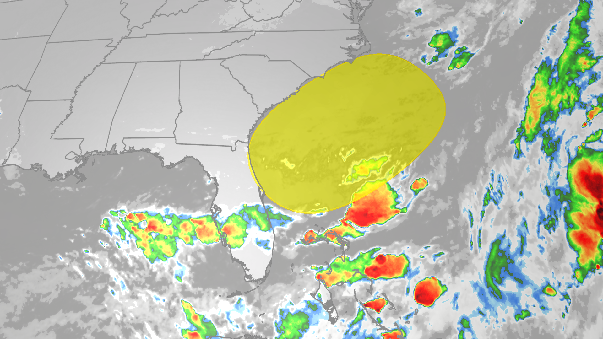
While the National Hurricane Center’s 5-day forecast keeps Invest 96-L east of the Bahamas, long-range ensemble models present three distinct possibilities for eventual U.S. impacts:
- Eastern Seaboard recurvature (55% probability): System turns northward away from land
- South Florida brush (25%): Outer bands impact Miami-Fort Lauderdale area
- Gulf of Mexico entry (20%): Potential for Texas/Louisiana threat if system survives crossing
Several atmospheric factors will determine the eventual path:
- Strength/duration of the Bermuda High pressure system
- Trough development along the U.S. East Coast
- Potential Fujiwhara interaction with nearby Invest 97-L
How 2025’s Hyperactive Hurricane Season Compares to Predictions

With four named storms already, the 2025 season is tracking NOAA’s above-average prediction of 18-22 named systems. Three unprecedented factors are driving activity:
- Record warm Atlantic temperatures (0.5°C above 2020 levels)
- Unexpectedly weak El Niño failing to suppress development
- Enhanced West African monsoon producing vigorous easterly waves
The Main Development Region between Africa and the Caribbean shows heat content comparable to September norms, exceptionally rare for August. This suggests early Cape Verde season activity typically seen in late summer.
September Outlook: Concerning Signals Emerging
Long-range climate models suggest alarming possibilities for peak season:
- 60% chance of major hurricane landfall in Caribbean
- Enhanced potential for October “Monster Month” outbreak
- Possible late-season Gulf storms continuing into November
Preparedness Steps for At-Risk Communities
Residents in potential impact zones should take these proactive measures immediately:
- Review evacuation plans: Know zone designations and routes
- Secure property: Trim trees, clear drains, reinforce garage doors
- Assemble supplies: 3-day water/food stocks, medications, batteries
- Document valuables: Photograph home contents for insurance
The time to prepare is when the sun shines – not when watches get issued. Caribbean islands should particularly focus on landslide mitigation and flood barriers given the region’s enhanced rainfall risks.
Comments