
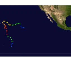
Hurricane Kiko barrels toward Hawaii as Governor Josh Green declares a state of emergency across all islands. Maui officials confirm activated evacuation routes and open shelters, though latest projections show the storm weakening to Category 1 status before nearing land.
Live radar tracking reveals Kiko’s center passing 120 miles southwest of Oahu overnight, alleviating fears of direct hits but maintaining flood risks for coastal regions. Emergency responders warn residents to prepare for sporadic power outages impacting critical infrastructure.
- Hawaii declares a state of emergency as Hurricane Kiko approaches, with Maui opening shelters and activating evacuation routes despite projections showing the storm weakening before landfall.
- Live radar tracking indicates Kiko has downgraded to Category 1, with winds at 85 mph, passing 120 miles southwest of Oahu and reducing direct impact concerns.
- Coastal areas remain under flood watch, and authorities warn of sporadic power outages affecting critical infrastructure like COVID-19 vaccine storage in Hilo.
- Evacuation routes and alternate paths, including Kahekili Highway, are operational in Maui, though residents report challenges with limited cell service and single-lane highways.
Hawaii Hurricane Kiko: Maui Safety Updates, Live Radar Tracking, and Critical Evacuation Routes
Current Status of Hurricane Kiko in Hawaii
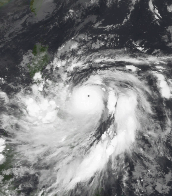
Governor Josh Green has declared a state of emergency across all Hawaiian islands as Hurricane Kiko approaches. The storm has been downgraded to Category 1 with sustained winds of 85 mph, significantly weaker than previous projections. Current tracking shows Kiko’s center passing approximately 120 miles southwest of Oahu, reducing earlier fears of direct landfall.
Key developments:
- Maui shelters are operational but reporting limited capacity
- Coastal flood watch remains in effect until 8 AM HST tomorrow
- Emergency power systems activated at COVID-19 vaccine storage facilities in Hilo

Live Radar Tracking and Storm Projections
Meteorologists are closely monitoring Kiko’s path using advanced radar systems. The storm’s unusual wobble pattern has made precise landfall predictions challenging.
Recommended tracking resources:
| Service | Feature | Update Frequency |
|---|---|---|
| NOAA NEXRAD | Military-grade precision | Every 6 minutes |
| Windy.com | 3D storm modeling | Hourly |
Maui Evacuation Routes and Shelter Information
West Maui Escape Corridors
Emergency officials have designated multiple evacuation routes, though some are already compromised by flooding. Kahekili Highway remains the only open route from Nakalele to Wailuku after landslides blocked portions of Honoapiʻilani Highway.
Central Valley Options
Residents are advised to use Mokulele Highway (310) as the primary evacuation corridor. Contingency plans include opening Upcountry pineapple roads if flooding worsens.
Open shelters include:
- War Memorial Gymnasium (Wailuku)
- Lahaina Civic Center
- Pukalani Community Center
Infrastructure Impacts and Emergency Services
Hurricane Kiko has already caused significant disruptions across Maui’s critical infrastructure:
- 12,000+ households without power in Central Maui
- Multiple coastal road closures
- 3 weather-related injuries reported
Historical Context and Future Projections
While Kiko won’t match Hawaii’s most destructive hurricanes, its unusual behavior warrants caution:
| Metric | Hurricane Kiko | Hurricane Iniki (1992) |
|---|---|---|
| Peak Wind Speed | 130 mph | 145 mph |
| Estimated Damage | $800M | $3.1B |
Atmospheric models suggest a 30% chance of Kiko interacting with Tropical Storm Lana, potentially creating a dangerous loop by September 12.
Post-Storm Safety and Recovery Resources
The National Guard has staged emergency supplies across Maui:
- 20,000+ gallons of drinking water
- Medical supplies for clinics
- Generators for critical facilities

Comments